Download PDF: Webinar Slides
Imagine that, as an underwriter, you could continuously monitor all the properties in your book of business, and quickly know when there has been a change in exposure. Imagine, as a claims manager, you could rapidly assess all your insured properties following a catastrophe, and make better-informed decisions as to where to most effectively allocate resources. This is not science fiction, but rather the new reality thanks to satellite imagery and new software tools to monitor and quantify changes in those images over time.
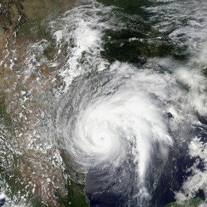
Hurricane Katrina, ten years later, remains a stark reminder of the challenges insurers face in responding to a severe catastrophe. This Advisen webcast, sponsored by Exogenesis and DigitalGlobe, examined the changes in claims management technology over the past decade, and demonstrated how, if Katrina were to happen again today, the outcome could be very different. But claims management is not the only insurance and risk management application for satellite imagery and other new technologies. Underwriting, loss control, and aggregation management all can benefit from an “eye in the sky” to keep track of changing exposures.
Exogenesis’ Sean Anklam, DigitalGlobe’s Kevin Lausten, Willis’ David Passman and Advisen’s Dave Bradford discussed how insurance and risk management are poised to be transformed by these emerging technologies.
Download the Satellite Derived Solutions from Katrina to Today webinar slides
![]()